Showing posts with label SAR. Show all posts

March 16, 2014

Chinese Military and "Dual-Use" Satellites

The use of Chinese ocean reconnaissance satellites to attempt to find Malaysian Airlines Flight MH370 prompted me to inquire about the capabilities of China's reconnaissance satellites. Such satellites are not specifically equipped to find crashed aircraft.  

China has steadily been developing and deploying a wide range of military-intelligence satellites and "dual-use" military-civilian use satellites. As will be indicated below the Chinese military (Peoples Liberation Army (PLA)) use satellites for:

- reconnaissance of sea (including submarines) and land "targets" including collection of all types of intelligence on China's potential or actual adversaries, 

- for anti-satellite and perhaps satellite repair purposes

- global positioning for military operations including ballistic and cruise missile guidance

- more specifically missile targeting of large US warships (see ISSSP article below) and US submarines 

- electronic (including signals) intelligence (ELINT) for military and counter-terrorism uses (the latter in support of the Ministry of State Security (MSS)).

"Dual-use" military-civilian use satellites very as to the proportion of military and civilian uses. Some satellites might be authentically dual use while other may be primarily or wholly military-intelligence use under the cover of civilian company ownership. Below are descriptions and links of some Chinese military and dual-use satellites.

Connect with a later March 23, 2014 sighting by Chinese dual-use satellite (Gaofeng-1) of possible MH370 debris http://gentleseas.blogspot.com.au/2014/03/mh370-australian-and-othe-aircraft.html 

After the glove-puppet histrionics of this 2019 Youtube above it is most useful to view it 2 minutes 20 seconds in.  China fields many reconnaissance "spy" satellite systems, including Shijiuns, Shiyans, Yaogans and  ZiyuansThe BeiDou or Beidou Navigation Satellite System (above) is also very military relatedI've bolded the names of satellites for easier reference.
---

The Chinese satellites can utilize their  ELINT sensors, Synthetic Aperture Radars (SARs) or electro-optical (EO) imaging sensors to detect submarines (submerged, snorkeling "snorting" or surfaced) - however their capabilities are unknown. If Chinese satellites become very efficient at detecting snorting Australian submarines (from the snorkel or near surface wake) these submarines may quickly become obsolete. Snorting-obsolescence is something for Australia's SEA 1000 decision makers to consider. Link with http://gentleseas.blogspot.com.au/2012/08/satellite-detection-of-submarines.html  

The 2049 Project in February 2014 produced the following commentary and list concerning reconnaissance satellites - http://www.project2049.net/documents/Chinas_Evolving_Reconnaissance_Strike_Capabilities_Easton.pdf
:

Satellite Platforms. To make up for its airborne platform deficiencies, the PLA has launched a large number of satellites that are capable of supporting theater missile operations with maritime reconnaissance data. These include electro-optical (EO) satellites for digital imagery in the visual and near infrared spectrum; synthetic aperture radar (SAR) satellites for nighttime, all-weather imagery; and electronic intelligence
(ELINT) satellites for locating and identifying ships by their electronic emissions. In 2012 alone, the PLA launched 11 new remote sensing satellites. It also launched three communications satellites and one relay satellite for beyond visual line of sight contact with ground stations. More recently, China launched its third series of naval ocean surveillance system (NOSS) satellites in September 2013.28 This underscores the key
role space-based ISR plays in supporting the PLA’s strike capabilities.29

Name Launch           Date                   Satellite Typ
Yaogan 9 (A,B,C)      Mar. 5, 2010       Naval Ocean Surveillance System (NOSS) 
Yaogan 10                 Aug. 10, 2010      Synthetic aperture radar (SAR) imagery 
Tian Hui 1A               Aug. 24, 2010      Military mapping satellite 
Yaogan 11                 Sep. 22, 2010      Electro-optical (EO) imagery 
Shi Jian 11-03            July 6, 2011         Unknown, possible early warning satellite 
Shi Jian 11-02            July 29, 2011       Unknown, possible early warning satellite 
Hai Yang 2A              Aug. 15, 2011      Dual-use ocean monitoring satellite 
Yaogan 12                 Nov. 9, 2011        Electro-optical (EO) imagery 
Shi Yan 4                   Nov. 20, 2011      Earth terrain mapping satellite 
Yaogan 13                 Nov. 30, 2011      Synthetic aperture radar (SAR) imagery 
Zi Yuan 1C                Dec. 22, 2011       EO or SAR imagery satellite 
Zi Yuan 3A                Jan. 9, 2012          Dual-use mapping satellite 
Feng Yun 2F              Jan. 13, 2012        Meteorological satellite 
Tian Hui 1B                May 6, 2012         Military mapping satellite 
Yaogan 14                 May 10, 2012       Electro-optical (EO) imagery 
Yaogan 15                 May 29, 2012       Electro-optical (EO) imagery 
Shi Jian 9 (A & B)     Oct. 14, 2012        Unknown military payload, possible ELINT 
Huan Jing 1C             Nov. 18, 2012       Synthetic aperture radar (SAR) imagery 
Xin Yan 1                  Nov. 18, 2012       Unknown, possible NOSS 
Feng Niao (1 & 1A)  Nov. 18, 2012       Unknown, possible NOSS 
Yaogan 16 (A,B,C)   Nov. 25,2012        Naval Ocean Surveillance System (NOSS) 
Gao Fen 1                 Apr. 26, 2013        Electro-optical (EO) imagery 
Shi Jian 11-05           July 15, 2013         Unknown, possible early warning satellite 
Yaogan 17 (A,B,C)   Sep. 1, 2013          Naval Ocean Surveillance System (NOSS) 
Feng Yun 3C             Sep. 23, 2013        Meteorological satellite 
Kuai Zhou                 Sep. 25, 2013         Rapid reaction imagery satellite 
Yaogan 18                Oct. 29, 2013         Synthetic aperture radar (SAR) imagery 
Yaogan 19                Nov. 20, 2013        Electro-optical (EO) imagery 
Sources: Gunter’s Space Page, Space Daily, Project 2049 Institute  

Professor S. Chandrashekar and Professor Soma Perumal of International Strategic & Security Studies Programme (ISSSP), National Institute of Advanced Studies (NIAS) Bangalore, India, have written China’s Constellation of Yaogan Satellites & the Anti-Ship Ballistic Missile – An Update (December 2013) http://isssp.in/wp-content/uploads/2014/01/Yaogan-and-ASBM-December-2013-Update.pdf

The Executive Summary (pp. ii-iii) is very informative – indicating the Anti-Ship Ballistic Missile of some of  China’s reconnaissance satellites. By their estimated resolutions the anti-submarine potential of the imaging satellites can be very roughly estimated. Executive Summary reads: 

"With the recent launch of the Yaogan 19 satellite China has in place an advanced space capability to identify, locate and track an Aircraft Carrier Group (ACG) on the high seas. This space capability is an important component of an Anti-Ship Ballistic Missile (ASBM) System that China has set up.

[see a list of all Yaogan satellites http://www.n2yo.com/satellites/?c=36 then, within that site, click on hyperlinks for each Yaogan satellite to get an animation of the real-time flight of each satellite - eg.  YAOGAN 17A http://www.n2yo.com/satellite/?s=39239 listed as an “intelligence gathering” satellite.]

The current 19 satellite constellation consists of ELINT [Electronic Intelligence] satellites, satellites carrying Synthetic Aperture Radar (SAR) sensors as well as satellites carrying optical imaging sensors.

Based on the orbit characteristics, their local time of equatorial crossing and other related parameters, these satellites can be grouped into different categories that perform the various functions for identifying, locating and tracking the ACG.

Yaogan 9 (Yaogan 9A, 9B, 9C), Yaogan (16A, 16B, 16C) and Yaogan 17 (17A, 17B, 17C) are the three clusters that are equipped with ELINT sensors that provide broad area surveillance over the Oceans. With a coverage radius of about 3500 Km, they provide the first coarse fix for identifying and locating an ACG in the Pacific Ocean.

Yaogan 13, Yaogan 10, Yaogan 18 and Yaogan 14 are the satellites carrying a SAR sensor. resolution of 1 to 3 m , they provide all weather as well as day and night imaging capabilities over the regions of interest.[perhaps able to detect a submarine's snorkel, periscope, wake and of course, surfaced shape]

Yaogan 11, Yaogan 4, Yaogan 2 and Yaogan 7 constitute the high resolution optical satellites in the current constellation. The sensors they carry may have resolutions of between 1 to 3 m. [perhaps able to detect a submarine's snorkel, periscope and of course, surfaced shape]

Yaogan 19 and Yaogan 15 optical imaging satellites with medium resolution (5 to 10 m) capabilities. [perhaps able to detect a submarine's surfaced shape]

The Yaogan 12 which replaced the Yaogan 5 has the orbital characteristics of a SAR mission. Yaogan 18 SAR satellite. Having two satellites spaced so close to each other makes it unlikely that it is a SAR mission. Most probably this is a high resolution optical imaging satellite that complements the broad area coverage provided by the 1200 km orbit of the Yaogan 15 and Yaogan 19 satellites.

This seems to be an important component of a larger Chinese Access and Area Denial Strategy focused around a conflict over Taiwan..." see WHOLE PAPER 
------------

Notes on satellites other than the Yaogan series are  http://claudelafleur.qc.ca/Scfam-reconnaissance.html#2014 :

-  SY-7 / Shi Yan 7, launched July 19, 2013 Orbit 666 km x 673 km x 98.1 with an anti-satellite and/or satellite maintenance mission: Shiyan-7 has a system for testing a manipulator arm to capture other space objects http://claudelafleur.qc.ca/Spacecrafts-2013.html#SY-7 About Chinese anti-satellite efforts generally see http://www.dailytech.com/Govt+Report+Warns+of+Chinese+Plans+to+Cripple+US+Space+Defenses/article23314.htm

-  ZY-3 / Zi Yuan III launched January 9, 2012 Orbit: 498 km x 506 km x 97.5° Ziyuan III is probably a 2,650-kg military photo surveillance satellite. It is reported that it is carrying an electro-optical imaging payload comprising three pointing forward, down and aft. The ground-facing camera has a resolution of 2.5 metres. The spacecraft also features an infrared spectrometer. According to Chinese press, Ziyuan II is a high-resolution remote-sensing satellite for civilian use” http://claudelafleur.qc.ca/Spacecrafts-2012.html#Ziyuan-III

-  ZY-1 02C / Zi Yuan I-02C launched December 22, 2011 Orbit: 770 km Mission: Ziyuan I-02C is probably a high-resolution military photo surveillance satellite. http://claudelafleur.qc.ca/Spacecrafts-2011.html#ZiyuanI-02C

-  SJ-6/4A / Shi Jian 6/4A and SJ-6/4B / Shi Jiun 6/4B  both launched October 6, 2010 588 km x 604 km x 97.8° Mission: Officially, the Shijian VI-04 group are designed to probe space environment But Shijian satellites are believed to have some kind of military surveillance role. They may also test technology demonstration and space research experiments. http://claudelafleur.qc.ca/Spacecrafts-2010.html#SJ-6/4A

-  The Beidou Navigation Satellite System is very Chinese military related. It consists of a limited test system that has been operating since 2000, and a full-scale global navigation system currently under construction. The full-scale global navigation system, officially called the BeiDou Satellite Navigation System (BDS) and also known as COMPASS or BeiDou-2, will be a global satellite navigation system consisting of 35 satellites. It became operational in China in December 2011, with 10 satellites in use, and began offering services to customers in the Asia-Pacific region in December 2012. It is planned to begin serving global customers upon its completion in 2020.
-
Pete
April 11, 2012

Satellite Detection of Submarines.


Please connect with Submarine Matter’s:


-  China Launches More Ocean Surveillance Satellites – October 3, 2014 http://gentleseas.blogspot.com.au/2014/10/china-launches-more-surveillance.html and

-  Chinese Military and “Dual-Use” Satellies – March 16, 2014 http://gentleseas.blogspot.com.au/2014/03/chinese-reconnaissance-surveillance-or.html
------------------------------

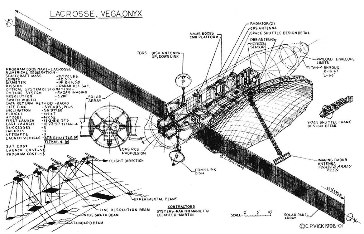
The US Lacrosse Satellite uses Synthetic Aperture Radar to see through cloud cover and is possibly sensitive enough to detect Chinese submarine snorkels, periscopes and wakes. Asia Times Online published this groundbreaking article US satellites shadow China's submarines on May 13, 2010, concerning satellite (and Space Shuttle) detection of submarines.

The article's author, Peter J Brown, is a a satellite journalist from Maine, USA who was part of the team that worked on the 1991 PBS documentary, Submarine: Steel Boats, Iron Men.

I've reproduced the whole long article, partly because articles with sensitive information have a habit of being quietly pulled off the Internet. My extra comments are between {....} brackets.

"US satellites shadow China's submarines

By Peter J Brown, May 13, 2010

The People's Liberation Army's Navy (PLAN) submarines cannot spot United States satellites high overhead as the submarines leave their bases at Sanya on Hainan Island, Qingdao in Shandong province and Ningbo in Zhejiang province, and head for deeper water. {However Chinese optical and radio telescopes on the ground can see the US Low Earth Orbiting (LEO) satellites in question and then transmit their presence to Chinese submarines. Chinese satellites may also be able to detect US satellites}.

Plenty of very deep water can be found in the South China Sea, {which is one reason why China built the Hainan-Sanya submarine base on the perimetre of the South China Sea} especially in the zone north of the Spratly Islands, east of the Paracels, and south of the Luzon Strait.

"A more challenging area for submarines to operate undetected is the East China Sea, which is quite shallow from the Chinese coastline up to the Okinawa Trough with a depth of only 30 to 60 fathoms {55 to 110 metres} in most places," said associate professor Peter Dutton with the China Maritime Studies Institute at the US Naval War College.

"Much of the water space [in the South China Sea] is more than 2,000 fathoms {3,658 meters}deep," said Dutton.

Detecting submarines via satellite is a form of Non-Acoustic Anti-Submarine Warfare (NAASW){see DARPA activity here . Lasers, infrared and other detectors and synthetic aperture radar (SAR) {such as the US "Lacrosse" satellite} in space may be used as part of this NAASW activity. Satellites might see subtle undersea disturbances caused by submarines, watch wave patterns on or beneath the sea surface, or detect subtle variations in ocean temperature.

This is not to be confused with satellite communications, nor is an "EO" or "Earth Observation" satellite to be confused with "EO" as in an "Electro-Optical" means of detecting submarines.

Over the next 18 months, the US National Reconnaissance Office (NRO) - operator of the US spy satellite fleet - is planning multiple satellite launches, and China must assume that one or more of these new US surveillance satellites will help support US Navy efforts to locate and track PLAN submarines.

Satellites form a network along with undersea sensors and detectors fixed on the sea floor or drifting in the open ocean as well as devices mounted on other submarines, ships, unmanned undersea vehicles (UUVs), aircraft, helicopters and unmanned aerial vehicles (UAVs).

Many are skeptical that satellites can perform NAASW missions effectively, reliably and at reasonable cost.

"The natural disturbances of the sea surface due to wind and tides, it seems to me, are very likely to mask any disturbance due to a submarine passage, and so even if this were a viable detection technique, it seems to me so limited in application that it would not be worth the investment," said one former US Navy sonar expert.

In April, a source told RIA Novosti, a Russian newspaper, that Russia had developed a novel satellite module "used for both defense and civilian purposes, in particular, providing meteorological data", and it can "carry out remote sensing of the sea and detect submerged submarines". This will be tested in space perhaps as early as next year. [1]

"Submarine detection, by any means, is a classified and highly guarded topic. The fact that the Russians are talking about it is the most interesting aspect of this announcement," said Brian Whitehouse, president of Nova Scotia-based OEA Technologies, Inc. He co-authored a paper with Daniel Hutt in 2008 about spaceborne sensors, ocean intelligence, and the maritime battlespace. [2]

The satellite in question is apparently the first of three small Russian Kanopus (Konopus) remote sensing satellites.

"This satellite is planned for 2011 and it will carry an Earth observing payload that includes a sensor for studying the underwater light environment," said Dr Jonathan McDowell, an astrophysicist at the Massachusetts-based Harvard-Smithsonian Center for Astrophysics who is also the editor of Jonathan's Space Report. "I cannot evaluate the claim that this will let them detect the wakes of submarines.{see Wavelet-Based detection algorithms obviously high tech and super-computer enabled} I do not believe that such technology is being used operationally at the moment {If it were it would be highly classified - perhaps on the USNS Impeccable with a bit of DARPA, USN Intelligence and NSA assistance}. I am not aware of relevant flight experiments, but they may have occurred."

Russia has previously demonstrated its satellite sub-hunting skills. Swedish satellite expert Sven Grahn identified the Russian Almaz-1 satellite which was launched in 1991 as a submarine-detection satellite that could see the surface wake or trail of a submerged sub. Besides this satellite, the Russians deployed other large, nuclear-powered and radar-equipped ocean surveillance satellites.

"Russian satellites known as RORSATs used radar to track surface ships, but the US Navy was not concerned that our subs could be detected, much less tracked. The signals, even if they existed, would be so wrapped into random noise that extracting any usable intelligence from them proved impossible," author James Oberg, a top US expert on Soviet and Russian space programs, told Asia Times Online. "The cancellation of that [Soviet] satellite program followed at least three accidental re-entries of debris. The laws of physics compelled them to orbit as low as possible, creating high air drag."

The theoretical boundary below which satellites cannot successfully maintain their orbits is approximately 160 kilometers above the Earth.

The Soviet space station Mir may have served as a platform for related research activities in the same way that the US Skylab once served as a platform for space radar testing in 1970s.

In the late 1990s, sub-hunting satellites made headlines. An American scientist, Peter Lee, was caught and convicted of passing sensitive information to China about the so-called Radar Ocean Imaging (ROI) joint project which involved the United K and the US. A decision by the US Navy based on concerns about further disclosures about the nature and scope of the ROI project echoes to this day.

"Peter Lee's case was they had this guy giving this very sensitive data to the Chinese on underwater detection of submarines. They ran into this case where the navy wouldn't allow a court case against him because of the data. So they had a bargain plea, and he got off, basically. For stealing very high-level stuff, he gets probably, what, a couple of months in a halfway house," former US ambassador to China, James Lilley, told PBS in 2004. [3]

China obtained relevant information from Russia, too.

"Chinese experts reportedly received technical assistance from Russian satellite experts in years following the Soviet Union's collapse," said associate professor Andrew Erickson at the China Maritime Studies Institute. "Specialists at the State Key Laboratory of Satellite Ocean Environmental Dynamics have researched ship detection using [SAR]."

Maritime surveillance became a top priority at the national level when China's so-called, "863 State High-Technology Development Plan" was activated. And China's fleet of Haiyang ocean surveillance satellites will grow to three when Haiyang-2A is launched later this year

Prior to the ROI program, the US SEASAT ocean satellite project which was launched by the US National Aeronautics and Space Administration (NASA) in 1978 carried a SAR into space for maritime surveillance purposes. After just over 100 days in space, SEASAT suddenly stopped working due to a short circuit in the design of its solar panels.

"Rumors suggested it had been turned off or sabotaged. There was a claim that SEASAT had mapped a field of World War 2-era shipwrecks on the floor of the English Channel," said Oberg.

A US Navy oceanographer from Australia, Paul Scully-Power, who became the first oceanographer in space, flew on the space shuttle Challenger (STS - 41G) in 1984. The US Navy later admitted that the mission had successfully detected the undersea or internal waves generated by a submarine which had been tracked successfully at relatively shallow depths. This was deemed, "incredibly important to us" and was reported by the Washington Post in 1985 - quoting a senior US Navy admiral at the time. [4]

In mid-May, by the way, the final flight of the space shuttle Atlantis (STS-132) will include a longtime submariner, US Navy captain Stephen Bowen.

According to naval analyst and author Norman Polmar, certain satellites can track submarine wakes, but are unable to do so continuously nor all the time, and not in all underwater environments. A submarine's depth, and speed along with the characteristics of the ocean bottom and water clarity, among other things, come into play here.

"A submarine is a relatively small, finite object - perhaps 300 to 500 feet [91 meters to 152 meters] in length in most cases - but the submarine's wake is persistent and stretches out for miles," said Polmar.

While the PLAN submarine fleet is the largest and most diverse in Asia, and very soon the fastest growing in the world, the PLAN's nuclear submarines are relatively easy to find. It is the diesel/electric submarines - and those equipped with so-called air-independent propulsion systems in particular - that are much harder to detect.

"The US Office of Naval Intelligence's unclassified July 2009 report on the PLAN suggests that some of the PLAN's diesel submarines are already extremely quiet, but its nuclear submarines remain relatively noisy," said Erickson.

US satellites play an increasingly important communications role in ASW, and are critical to the US Navy's Persistent Littoral Undersea Surveillance Network (PLUSNet), ForceNet and Sea Shield programs, to name a few. In addition, the US Defense Advanced Research Projects Agency (DARPA) is funding the Tactical Relay Information Network which uses lasers to instantly beam vital messages to submerged US subs as they are underway and perhaps chasing down other subs.

This writer speculates that as many as a dozen countries have operated sensors aboard satellites involved in some form of NAASW research. Others may disagree with this assessment.

Whitehouse and Hutt, for example, stated that, "many of these sensors are not of immediate practical benefit to military operations".

Keep in mind that commercial satellite ventures, and public - private partnerships such as Germany's RapidEye AG offer all sorts of satellite imagery.

Smaller, less expensive satellites possibly flying in formation over the ocean may offer significant advantages here. They can train their sensors and cameras on a single spot as they pass by in formation. California-based Microcosm Inc, for example, is developing the NanoEye small-satellite system, which comes equipped with basic or advanced electro-optical and infrared sensor payloads.

"Smaller satellites flying in formation may seem attractive for reasons of cost and coverage, but larger satellites offer far more advantages in terms of real capabilities," said Polmar. "Simply because of their small size, the smaller satellites are less capable, offer less electrical power and you cannot put much on them unlike much larger satellites."

The real advantage comes from the entire satellite-enabled infrastructure - or systems of systems - which links the powerful space-based sensors and detectors with those mounted on surrounding ships, subs, UUVs, aircraft, helicopters and UAVs - including the new "Sea Avenger" - so that all this surveillance data merges together to form a "common undersea picture" which can be instantly shared across the entire ASW community.

Aircraft and UAVs lingering overhead can mimic surveillance satellites, and their presence is an important aspect of the US "Maritime Domain Awareness" strategy. Another option involves inserting additional maritime surveillance assets above conventional aircraft and UAVs, and beneath the satellites.

For example, the US Navy is interested in DARPA's "Integrated Sensor Is the Structure" (ISIS) program, which is, in effect, an integrated stratospheric airship/radar - the stratosphere is found at an altitude of roughly 10 to 50 kilometers above Earth - featuring a 600-kilometer-wide sensor radius. In fact, DARPA included a slide during a briefing last year that showed how a single ISIS on station over the Luzon Strait could conduct surveillance operations covering the entire Strait from Taiwan to the northern Philippines, and almost as far west almost as the coast of China.

"No single sensor/platform combination has all the answers. Every sensor has its limitations. As a result, each application usually involves a suite of sensors, platforms and computer-based models," said Whitehouse and Hutt.

Associate professor Kazuto Suzuki of Hokkaido University's Public Policy School described Japan's Maritime Self Defense Force (MSDF) as "one of the best ASW forces without using satellite capability".

"There is no discussion of a satellite infrastructure for ASW. Satellites are only useful for detecting activities [at submarine bases]. MSDF and the 7th Fleet of the US Navy are sharing the work for ASW, and there is a strong confidence between them," said Suzuki.

However, over the years, Japan has launched many advanced remote sensing/earth observation, meteorological, and engineering test satellites - exactly the types of satellites which are ideally suited for conducting satellite-based NAASW research and development.

One relevant joint NASA-Japan Aerospace Exploration Agency project on the International Space Station recently tested a maritime hyperspectral imager. This coincided with work on the same type of imager done as part of the US Navy's Tactical Space Innovative Naval Prototype program involving so-called TacSats and their maritime satellite links to buoys and "unattended" sensors - perhaps UUV-mounted sensors.

China routinely uses ocean-centric satellite imagery provided by the US, Japanese and Europeans. Their own undersea mapping projects such as one done recently as part of a larger and more comprehensive Chinese survey of the South China Sea rely heavily on access to this data. [5]

The world's vast oceans have not been rendered completely transparent, but for over three decades, satellites have been transforming the way we view them.

As the US Congress scrutinizes the US-Russian START (Strategic Arms Reduction Treaty) successor and possible restrictions on the future use of US submarine launch tubes for anti-missile purposes, new potential threats to submarines need to be examined carefully.

Finally, the sinking in March 2010 of the South Korean destroyer Cheonan - important evidence in the form of "satellite imagery" is surfacing although the investigation is still underway [6] - serves to remind everyone that work must continue to help thwart future surprise attacks.

Notes

1. Hotlink here Russia to build submarine-detecting satellite, RIA NOVOSTI, Apr 15, 2010.

2. Ocean intelligence in the maritime battlespace: the role of spaceborne sensors and hf radar, Canadian Military Journal, July 14, 2008.

3. PBS interviews James Lilley, PBS.org, June 4, 2003.

4. "Shuttle Flight Yields Data on Hiding Subs," The Washington Post, March 22, 1985, p A10. (Not available online.)

5. Using satellite data to map coral reefs in the South China Sea, Spie, February 21, 2007.

6. South Korea Concludes That North Korea Sank Ship, Chosun Says, Bloomberg.com, May 7, 2010."

A big thankyou to Asia Times Online (Holdings) Ltd for originally publishing the article at http://www.atimes.com/atimes/China/LE13Ad01.html . Australia by the Indian Ocean is a free, non-profit, blog, accessable to all.
-
PETE'S COMMENT

Link with the following on this "gentleseas" website

LIDAR an anti-submarine warfare sensor, January 16, 2014, http://gentleseas.blogspot.com.au/2014/01/lidar-anti-submarine-warfare-sensor.html

The DASH Program anti-submarine sensors - TRAPS & SHARK, April 8, 2013, http://gentleseas.blogspot.com.au/2013/04/the-dash-program-anti-submarine-sensors.html , and

-
Pete